- Página de inicio /
- Hogar y cocina /
- Wall Art /
- Posters & Prints /
- National Geographic: India Classic Wall Map - 23.5 x 30...
0 ratings




Nº de artículo:
44577084
National Geographic: India Classic Wall Map - 23.5 x 30.25 inches - Rolled Canvas
Nº de artículo:
44577084
USD 131
Price Details
Excluding Shipping & Custom charges ( Shipping and custom charges will be calculated on checkout )
*All items will import from Estados Unidos
0 ratings
Escribe una opinión
En stock
 Importado de la tienda USA
QTY:
Haz tu pedido ahora y recíbelo por ahí Jueves, Octubre 22
Secured transaction
Ubuy works hard to protect your security and privacy. Our advanced payment security system ensures confidentiality by encrypting your information during transmission using AES (Advanced Encryption Standards) and SSL (Secure Socket Layer) protocols. Your payment details are 100% secure as we do not share your payment details with third party sellers.
Our Top Logistics Partners


National Geographic's maps are the standard others are measured against.

Fast
Shipping

Free
Return*

Secure Packaging

100% Original Products

PCI DSS Compliance

ISO 27001 Certified




What Stands Out
Detailed Cartography
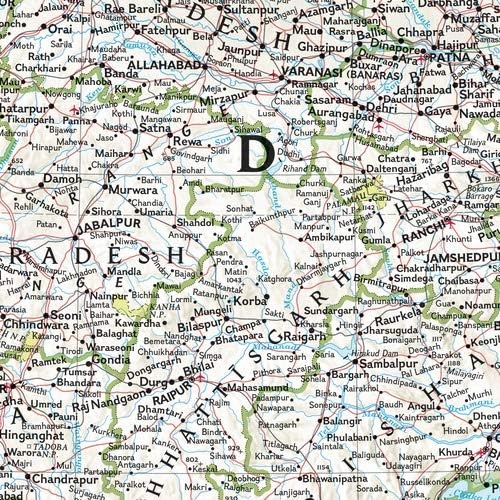
This wall map showcases intricate geographical details, making it a perfect educational tool for learners and a decorative piece for enthusiasts who appreciate the diverse landscapes of India.
Quality Canvas Material
Printed on durable rolled canvas, this map resists wear and tear while adding an elegant touch to any space, enhancing both aesthetics and longevity compared to paper maps.
Large Format
Measuring 23.5 x 30.25 inches, this large-format map provides ample visibility and readability, ideal for classrooms, offices, or personal spaces, allowing for an immersive experience of India's geography.
Detalles de producto
- Perfect tool for classrooms to help students understand world geography
- Ideal size for a gallery wall collection, adds a pop of color
- Printed on canvas for high-quality artistic display
- Ready to be framed with spare canvas on each side
- Meticulously researched and adheres to National Geographic's standards
- Includes physical features for a genuine feel and navigation skill development
| Brand Name | National Geographic |
| Map Type | Physical, Political |
| UPC | 749717046023 |
| Manufacturer | MapSherpa |
| Paper Size | 23.5 x 30.25 inches |
| Item Dimensions L x W | 23.5"L x 30.25"W (59.7 x 76.8 cm) |
| Brand | National Geographic |
| Sheet Size | 23.5 x 30.25 inches |
| Product Dimensions (L x W x H) | 23.5"L x 30.25"W (59.7 x 76.8 cm) |
Who Should Buy?

-
Educators
Perfect for teachers who want to visually enhance geography lessons and foster a better understanding of India's topography.
-
Travel Enthusiasts
Ideal for individuals planning trips to India, providing detailed insights into regions, culture, and geography of the country.
-
Home Decorators
Great for those looking to add an educational yet stylish element to their home office or living space.

-
Casual Users
Less suitable for those who only require basic map information or incidental references when discussing India.
DESCRIPCIÓN DEL PRODUCTO
About This Item
Introducing the National Geographic: India Classic Wall Map - a must-have for geography enthusiasts, educators, and anyone interested in discovering the beauty of India. This stunning map showcases India's political and physical features with unrivaled detail and accuracy. The state-of-the-art cartographic techniques used in its creation ensure exceptional quality, making it a valuable resource for classrooms and teaching environments. With its engaging design and user-friendly layout, this map allows for easy navigation and understanding of India's geography.
Students can develop their navigation skills using latitude and longitude, as well as explore political boundaries within the country. Featuring a bright and easy-to-read color palette, including blue oceans and stunning shaded relief, this map embodies the classic National Geographic aesthetic that has been trusted by educators for over 75 years. The Transverse Mercator projection enhances its navigational capabilities, making it ideal for regions near the equator. The names of political and geographic features are carefully placed to maintain legibility. With meticulous research and adherence to National Geographic's convention of independent, apolitical decisions based on extensive research from multiple authoritative sources, this map sets the standard for reference maps. Printed on high-quality canvas, this map not only provides accurate information but also showcases the artistic quality of National Geographic's iconic wall maps.
Additionally, five inches of additional material on each side ensure that you have enough material to stretch the map on a frame without compromising its integrity. To safeguard this valuable piece of cartography during shipment, your map will be rolled and packaged in a sturdy tube. Rest assured that it will arrive in pristine condition, ready to adorn your wall and inspire exploration. Experience the beauty and educational value of the National Geographic: India Classic Wall Map. Whether you're a teacher, student, or simply an admirer of India's rich geography, this map is an essential addition to your collection.
Explore the wonders of India and embark on a journey of discovery today.
¿Tienes alguna consulta? Chatea con nosotros
Preguntas y respuestas de los clientes
-
Pregunta:
What are the dimensions of the National Geographic: Ecuador Classic Wall Map?
Respuesta: The National Geographic: Ecuador Classic Wall Map measures 23.5 x 30.25 inches. This size makes it an ideal choice for wall display, providing a clear and comprehensive view of Ecuador's geographical features, major cities, and significant landmarks. Its larger format allows for more detailed illustrations and easy readability, making it perfect for educational use in classrooms or as a decorative piece in homes. Whether you're a geography enthusiast or simply looking to beautify your space, this map serves both functional and aesthetic purposes. -
Pregunta:
What material is the National Geographic Ecuador Wall Map made of?
Respuesta: The National Geographic Ecuador Classic Wall Map is made of high-quality rolled canvas. This material ensures durability and a premium look, making it resistant to wear and tear over time. Canvas also allows for vibrant color reproduction, ensuring that geographic details are clearly visible and attractive. Its rolled form simplifies storage and transportation, making it easy to handle. Perfect for anyone wanting a long-lasting, visually appealing map that can be showcased in various settings, including homes, offices, or educational spaces. -
Pregunta:
Can this map be framed easily?
Respuesta: Yes, the National Geographic: Ecuador Classic Wall Map can be easily framed. Its dimensions of 23.5 x 30.25 inches fit standard-sized frames, which makes finding an appropriate frame convenient. Framing the map not only enhances its visual appeal but also protects it from dust and damage. Many customers opt for a frame to display it in their living rooms or offices, creating a focal point that sparks conversation and provides a stylish way to showcase their interest in geography. -
Pregunta:
Is this map suitable for educational purposes?
Respuesta: Absolutely! The National Geographic: Ecuador Classic Wall Map is ideal for educational purposes. Its detailed geographical representation includes significant cities, rivers, mountains, and borders, making it a helpful tool for students and educators alike. Teachers often use this map to facilitate lessons on geography, culture, and history. Additionally, it's great for interactive learning, where students can locate states or cities, making geography engaging and informative in classrooms. -
Pregunta:
Will this map fade over time if displayed in sunlight?
Respuesta: While the National Geographic: Ecuador Classic Wall Map is printed on durable rolled canvas, like any print, it may be susceptible to fading if exposed to direct sunlight over prolonged periods. To preserve its vibrant colors and longevity, it is recommended to hang it in a location that receives indirect light or to use UV-protected glass if framed. Many users choose to display it in offices or study rooms where the light is controlled, ensuring the map retains its stunning visual for years. -
Pregunta:
What locations are highlighted on the National Geographic Ecuador Wall Map?
Respuesta: The National Geographic: Ecuador Classic Wall Map highlights a comprehensive array of geographical features, including major cities, rivers, mountain ranges, and state boundaries. Key locations like Delhi, Mumbai, Kolkata, and Bangalore are prominently marked alongside important national parks and landmarks. This makes it not only a functional tool for understanding the layout of Ecuador but also an insightful reference for those interested in traveling or learning more about the rich diversity and culture of Ecuador. It's often used in travel planning to identify destinations. -
Pregunta:
Is this map waterproof or water-resistant?
Respuesta: The National Geographic: Ecuador Classic Wall Map, while printed on canvas, is not waterproof or water-resistant. It is designed primarily for display purposes. Therefore, it is advisable to keep it away from moisture or damp areas. Users may opt to laminate it or use a protective spray if they intend to have it in a more exposed environment. Many customers find it makes a great addition to living rooms, offices, or schools, as long as it's displayed in a suitable, dry location. -
Pregunta:
How can I clean the National Geographic Ecuador Wall Map without damage?
Respuesta: To clean the National Geographic: Ecuador Classic Wall Map without causing damage, use a soft, dry cloth to gently dust off any particles. For more stubborn stains, lightly dampen the cloth with water to avoid soaking the canvas. It’s crucial to avoid using harsh chemicals or scrubbing, as these could damage the print. Maintaining the map's cleanliness enhances its aesthetic and longevity, making it an enchanting addition to any wall display, whether in personal collections or educational settings. -
Pregunta:
Can I purchase this map online?
Respuesta: Yes, you can purchase the National Geographic: Ecuador Classic Wall Map online. It is available at various e-commerce platforms. In Ecuador, you can conveniently buy this map from Ubuy, which offers a simple shopping experience along with fast delivery options. Whether you’re looking to enhance your home decor or need a functional map for educational purposes, Ubuy provides easy access to this classic wall map. -
Pregunta:
What themes or styles does the map depict?
Respuesta: The National Geographic: Ecuador Classic Wall Map depicts a traditional yet visually appealing style, characterized by its vibrant colors and detailed geographical features. The map showcases various themes such as political boundaries, significant cities, and physical landscapes like mountains and rivers. This classic design makes it an excellent choice for those who appreciate not only functionality but also artistry in cartography. Perfect for both educational environments and home décor, it adds a touch of sophistication to any space while serving as an informative reference.
National Geographic Posters & Prints Editorial Review
National Geographic: India Classic Wall Map - 23.5 x 30.25 inches - Rolled Canvas offers a stunning visual representation of both physical and political features of India, crafted with the quality that National Geographic is renowned for. The canvas material enhances durability and aesthetics, making it a great addition to any room. The map measures 23.5 x 30.25 inches, making it suitable for wall displays. It's perfect for educational purposes, home decor, or for someone with an appreciation for geography. This rolled canvas map is not only decorative but also functional for learning and exploration of the diverse Indian subcontinent.
Customer Reviews & Ratings
1 valoraciones de los clientes
-
5 estrella
100%
-
4 estrella
0%
-
3 estrella
0%
-
2 estrella
0%
-
1 estrella
0%
Revisar este producto
Comparte tus ideas con otros clientes
ventajas
- High-quality canvas material for durability
- Detailed physical and political features
- Ideal for educational and decorative use
- Appropriate size for wall display
- Reputable brand known for quality maps
Contras
- Limited design options available
Platform Trust & Buyer Confidence

JK
Jasmin
Verified buyer
“Great products and very good service: very easy and very fast international delivery.”
9 September 2026 · via Trustpilot
AG
Anke
Verified buyer
“Wonderful online shopping experience, smooth transaction from the start. Payment method works conveniently and delivery is unexpectedly fast and reliable. You go the extra mile for service. What makes this even more amazing, you deliver to Namibia. I will remain a happy Ubuy customer and will increase my purchases for sure! Thank you!”
10 September 2026 · via Trustpilot
H
Hazel
Verified buyer
“Very easy to find the products what you need, and so fast delivery, that’s why I highly recommended to others costumers to used ubuy.”
10 September 2026 · via Trustpilot
O
Opaleye
Verified buyer
“I received exactly what I ordered I was skeptical about your site because that was my first time to order. But the order came timely and neatly packaged. I was not disappointed. Thank you.”
11 September 2026 · via Trustpilot
AC
Adele
Verified buyer
“Easy to find and order what you want on the website. Delivery is quick to the UK”
8 September 2026 · via Trustpilot
Pago seguro
Global Delivery
Easy Returns
Genuine Products
Product Price History
Información importante
- Limitaciones: Para los productos enviados al extranjero, ten en cuenta que cualquier garantía del fabricante puede no ser válida; las opciones de servicio del fabricante pueden no estar disponibles; los manuales del producto, las instrucciones y las advertencias de seguridad pueden no estar en los idiomas del país de destino; los productos (y los materiales que los acompañan) pueden no estar diseñados de acuerdo con las normas, especificaciones y requisitos de etiquetado del país de destino; y los productos pueden no ajustarse al voltaje del país de destino y a otras normas eléctricas (lo que requiere el uso de un adaptador o convertidor, si procede). El destinatario es responsable de asegurarse de que el producto puede ser importado legalmente al país de destino. Cuando hagas un pedido a Ubuy o a sus filiales, el destinatario es el importador registrado y debe cumplir todas las leyes y normativas del país de destino.
- No todos los productos que aparecen en Ubuy están a la venta, ya que Ubuy es un motor de búsqueda a nivel mundial. Los productos están sujetos a las normas de exportación/comercio.
USD 131
Haz tu pedido ahora y recíbelo por ahí Jueves, Octubre 22
This item is not restrict in my country.(Please click on above link if this item is not restrict in your country, So our team will review and allow.)
QTY:
Secured transaction
PCI DSS compliant and ISO 27001:2022 certified, with encrypted payments and full buyer protection on every order.
Our Top Logistics Partners
Fastest cross-border delivery
características y beneficios
- Classic India map showcasing the country in stunning detail.
- Ideal for classrooms with an emphasis on teaching geography or environmental themes.
- Perfect to help students develop navigation skills using latitude and longitude and political boundaries.
- Printed on high-quality canvas for artistic display in homes, schools, or offices.
- Includes 5 inches of additional material on each side to stretch the map on a frame.
- National Geographic maps adhere to the highest quality and accuracy standards.
Ubuy Assurance
Experience worry-free shopping with 100% original products, PCI DSS-compliant payment security, ISO 27001-certified data protection, the fastest cross-border delivery, free returns *, and secure packaging on every order.